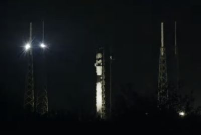
NASA New Satellite Missions: To Study and Predict Extreme Weather and Climate [PHOTOS]
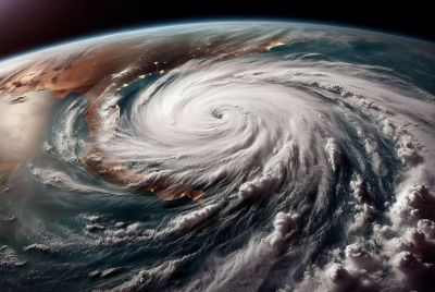
With extreme weather and climate conditions affecting a lot of people in the world nowadays, such as the devastating effects of Typhoon Haiyan on the Philippines and Vietnam, the need to know more about what it is and how to prevent it is even more important. Thanks to the National Aeronautics and Space Administration (NASA) new Satellite Missions, studying and predicting extreme weather and climate will now be easier and more accurate. Hopefully, it can help people to prepare earlier by evacuating to safer areas and stocking up on food and water supplies to last them for several days until the calamity has passed.
These NASA Satellite Missions, including the Terra (EOS AM) satellite and the Aqua (EOS PM) satellite, use space-based navigation and communication such as the Moderate Resolution Imaging Spectroradiometer (MODIS) to give us different views of the Earth's surface. MODIS also provides validated, global and interactive system models of the Earth that allow them to predict global change faster and more accurately. This technology enables NASA to warn against impending disaster so that those who will be greatly affected can prepare, make sound decisions and constantly protect the environment to minimise disastrous effects.
The Terra (EOS AM) satellite passes from north to south across the equator in the morning while the Aqua (EOS PM) satellite passes from south to north over the equator in the afternoon.
The data collected from these Satellite Missions will help us in understanding the Earth and its atmosphere better.
Here are the new NASA Satellite Earth Observation Missions that focus on studying the Earth, including its weather and climate:
1. SMAP (Soil Moisture Active Passive) - provides soil moisture global measurements including its freeze/thaw state. This will help us understand the water, carbon and energy cycle links and improve weather and climate prediction. This will also provide even more accurate information on water resource availability. Check out the Spacecraft Assembly Facility (SAF) Live Webcam Overview to see the SMAP spacecraft being built.
2. ISS-RapidScat - will measure the Earth's ocean surface wind speed and direction, including hurricane monitoring and weather predictions. It will be launched in 2014 aboard the International Space Station (ISS).
3. Orbiting Carbon Observatory (OCO)-2 - will study the carbon dioxide (CO2) of the atmosphere from Space. It will be NASA's first dedicated Earth remote sensing satellite to do so. It will also quantify the variability of CO2 over the seasonal cycles every year. Plus, it will collect atmospheric CO2 space-based global measurements to characterize sources and sinks on regional scales.
4. Jason-3 - will measure the height of the ocean surface and extend the ocean surface topography measurement time series. This is important for scientists to know more about the ocean's circulation patterns, sea level changes (global and regional) and climate implications of global warming. It will be launched in 2015.
Other NASA Missions including the Global Precipitation Measurement (GPM), Gravity Recovery and Climate Experiment (GRACE) and the Tropical Rainfall Measuring Mission can be seen at the NASA Web site on the NASA Missions page.
Check out other NASA environmental programs here. You can also check out NASA's Eyes on the Earth site to see 3D displays of almost real-time data from Earth-observing missions. To hear from the teams involved in some of these NASA Missions, you can click this video.
Disasters brought about by natural calamities are inevitable but these new NASA Satellite Missions that will study and predict extreme weather and climate conditions can really help us prepare even better than before.
- Check out Super Typhoon Haiyan Related News:
Super Typhoon Haiyan Update: More Ways to Reach Out and Help Filipinos
- MOST POPULAR IN Science