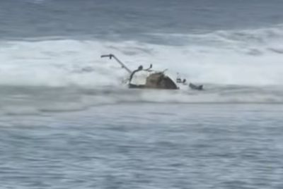
Massive Waterspout in Australia Captured on Video
Australians have witnessed Mother Nature's wrath when a massive waterspout formed for about 20 minutes on Batemans Bay in New South Wales. Several footages of the waterspout, where stunning images of the dark grey whirling vortex was captured, quickly circulated on social networking sites.
Though there were no reports of damages, forecasters claim that the waterspout is just the beginning of an alarming weather conditions in the area where thunderstorms, heavy rain and winds of up to 100km/h have been recently experienced by residents. More than 24,000 lightning strikes were recorded over the weekend.
Mick Logan, a Bureau of Meteorology severe weather forecaster, stated the waterspout garnered so much attention because it was mostly well-formed and intense. "It's the most intense that I've seen off the NSW coast. There's not many photos that I would know of that have come in with something as strong as that one," Logan told the Australian Associated Press. In an AAP report, the last waterspout spotted was in February off the coast of Medowie, north of Newcastle.
According to Logan, waterspouts are usually seen in late autumn on Australia's east coast due to the warmer sea temperature and cooler air. "But in the digital age, there's more and more footage coming in of them," Logan further added.
Peter Zmijewski, senior meteorologist at Australia's Bureau of Meteorology, said waterspouts are unpredictable and they only develop in certain conditions. ''They are impossible to forecast,'' Zmijewski stated. Zmijewski also added that waterspouts do not suck up water and they can be produced due to wind shear differences in wind speed or direction over short distances.
Take a look at the video footage below of the November 2012 Monster Waterspout/Water Twister captured at Batemans Bay in Australia.
- MOST POPULAR IN Society